|
|
C&O Division
Big Coal Subdivision
(Whitesville, WV to Sproul, WV)
|
Big Coal Subdivision-BX
Station List and Diagram
This information comes from the 'CSX Transportation C&O Division Timetable No. 1', effective Saturday, January 1, 2000.
|
|
Radio: BJ Dispatcher channel 14, Road channel 08 |
|
35.6 Miles · Sproul Junction to Jarrolds Valley Junction |
| â WEST â |
MP |
Station |
Siding |
Notes |
 |
CLL35.6 |
Jarrolds Valley Jct |
|
Jct Big Marsh Fork SD
Begin Big Coal SD |
| CLL34.8 |
Whitesville |
|
|
| CLL33.5 |
Elk Run Junction |
|
|
| CLL21.0 |
Sylvester |
|
End of Main Track |
| CLL26.9 |
Keith |
|
|
| CLL24.6 |
Orgas |
7886' |
|
| CLL20.9 |
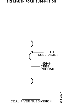
Seth |
|
Jct Seth SD |
| CLL19.1 |
Joe Creek |
|
|
| CLL13.7 |
Indian Creek |
|
Jct Indian Creek Industrial Track |
| CLL7.0 |
Bull Creek |
|
|
| CLL2.0 |
Brounland |
5342' |
|
| CLL1.2 |
Big Coal |
|
|
| CLL0.0 |
Sproul |
|
End Big Coal SD
Jct Coal River SD |
| Authority for Movement |
|---|
| Between Location/Mile Post |
Rules |
| CLL0.0 and CLL2.0 |
265-271 |
| CLL2.0 and CLL31.1 |
120-132 |
| Note: Westward signal, located at MP CLL3.5 is equipped with an APP plate. This signal only conveys information about WAS signal at MP CLL2.0. |
| |
DTC Block Limits
Between CLL2.0 and CLL31.0 |
|---|
| Between Location/Mile Post |
Block Names |
| CLL2.0 and CLL8.0 |
Bull |
| CLL8.0 and CLL19.2 |
Ash |
| CLL19.2 and CLL20.8 |
Ind |
| CLL20.8 and CLL24.6 |
Oak |
| CLL24.6 and CLL26.6 |
Orgas |
| CLL26.6 and CLL31.0 |
Keith |
| |
| Maximum Authorized Speed |
|---|
| Between Location/Mile Post |
MPH |
| CLL0.0 and CLL31.0 |
25 |
|
Copyright © 2002 by Steven L. Miller. Reproduction is prohibited without permission.
This site is not affiliated with CSX Transportation, and is intended for informational purposes only.
Last updated - June 15, 2002
|


