|
|
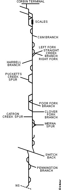
Appalachian Division
CV Subdivision
(Corbin, KY to Big Stone Gap, VA)
|
CV Subdivision-CV
Station List and Diagram
This information comes from the 'CSX Transportation Appalachian Division Timetable No. 1', effective Saturday, January 1, 2000.
|
|
Radio: BK Dispatcher channel 94, Road channel 84 |
|
122.4 Miles · Corbin Terminal to End of Main |
| â SOUTH â |
MP |
Station |
Siding |
Notes |
 |
C172.0
CV172.0 |
Corbin Terminal |
|
Jct CC SD, Jct KD SD
Begin CV SD |
| CV175.0 |
Siler |
|
NEDT |
| CV179.9 |
Arkle |
|
SEDT |
| CV185.1 |
Baileys |
4332' |
|
| CV186.8 |
Heidrick |
|
Jct C&M Branch |
| CV189.9 |
Barbourville |
8110' |
|
| CV202.9 |
Pineville |
8718' |
Jct Straight Creek Branch |
| CV205.7 |
Harbell |
|
Jct Harbell Branch |
| WB211.8 |
Varilla |
7812' |
Jct Yellow Creek Spur |
| WB221.8 |
Felder |
|
NEDT |
| WB224.5 |
Blackmont |
|
SEDT, Jct Puckett Creek Spur |
| WB236.0 |
Wilhoit |
|
|
| WB240.0 |
Loyall |
|
NEDT |
| WB240.2 |
Baxter |
|
Jct Poor Fork Branch |
| WM242.1 |
Harlan Junction |
|
SEDT, Jct Clover Fork Branch |
| WM243.0 |
Dressen |
|
Jct Catron Creek Spur |
| WM248.6 |
Glidden |
6806' |
Jct Merna Spur |
| WM250.5 |
Popeville |
|
|
| WM253.8 |
Flagler |
3738' |
|
| WM258.4 |
Smiley |
2360' |
|
| WM243.6 |
Hagans |
|
Switch Back |
| CV248.5 |
Hubbard Springs |
5491' |
|
| CV260.1 |
Pennington |
6374' |
Jct Pennington Branch |
| CV265.1 |
Dryden |
|
|
| CV276.2 |
Big Stone Gap |
5461' |
|
| CV277.3 |
End of Mainline |
|
Jct NS |
| The distance between Smiley and Hagans via Switch Back is 1.7 miles. |
| Authority for Movement |
|---|
| Between Location/Mile Post |
Rules |
| Siler and WB238.6 Loyall |
265-272 |
| WB238.6 Loyall and WB242.1 |
93 |
| WB242.1 and WB256.5 |
120-132 |
| WB256.5 and WB258.2 |
120-132 (243-246) |
| WB258.2 to End of Track including switchback tracks and CV242.0 and CV244.7 |
93 |
| CV244.7 and CV274.9 |
120-132 |
| Big Stone Gap |
|---|
| CV274.9 and CV276.2 |
93 |
| CV276.2 and CV277.6 |
93 (243-246) |
| C&M Branch |
|---|
| CV/CQ186.9 and CQ208.0 Manchester |
120-132 |
| CQ208.0 Manchester and CQ209.5 End of Track |
93 |
| CF208.7 Horse Creek and CF211.6 End of Track |
93 |
| Straight Creek Branches |
|---|
| SC202.9 and SC203.1 Pineville Wye |
93 |
| SC203.1 and End of Track (Right Fork) |
120-132 |
| SF204.6 and End of Track (Left Fork) |
120-132 |
| Harbell Branch |
|---|
| CV205.7 and CV215.0 |
120-132 |
| Loyall Yard |
|---|
| WB238.6 and WM242.1 Harlan Junction |
93 |
| Poor Fork Branch |
|---|
| WC240.2 and WC263.7 End of Track |
120-132 |
| Scotia Branch |
|---|
| WC/WD262.3 and WD272.9 |
120-132 |
| Clover Fork Branch |
|---|
| WH242.1 Harlan Junction and WH269.6 |
120-132 |
| Pennington Branch |
|---|
| CV/CH259.9 and CH261.9 |
S-146 |
| |
DTC Block Limits
Between Harlan Junction and Big Stone Gap |
|---|
| Between Location/Mile Post |
Block Names |
| WM242.1 and WM247.3 |
Glidden |
| WM247.3 and WM250.6 |
Popeville |
| WM250.6 and WM256.5 |
Flagler |
| WM256.5 and WM258.2 |
Smiley |
| CV244.7 and CV247.6 |
Hubbard Springs |
| CV247.6 and CV258.7 |
Pennington |
| CV258.7 and CV274.9 |
Big Stone Gap |
| C&M Branch |
|---|
| CQ186.9 and CQ196.2 |
Heidrick |
| CQ196.2 and CQ203.2 |
Fount |
| CQ203.2 and CQ208.0 |
Park Valley |
| Straight Creek Branches |
|---|
| SC203.1 and SC204.6 |
Straight Creek |
Right Fork:
SC204.6 and SC208.8 |
Holden |
| SC208.8 and SC215.1 |
Fleenor |
| SC215.1 and SC218.0 |
Hamilton |
| SC218.0 and End of Track |
Clover |
Left Fork:
SF204.6 and SF208.6 |
Lusby |
| SF208.6 and SF213.3 |
Hanby |
| SF213.3 and End of Track |
Kay |
| Harbell Branch |
|---|
| CV205.7 and CV215.0 |
Harbell |
| Poor Fork Branch |
|---|
| WC240.2 and WC255.0 |
Baxter |
| WC255.0 and WC259.8 |
Chad |
| WC259.8 and WC263.7 End of Track |
Lynch |
| WC/WD262.3 and End of Track (Scotia Branch) |
Scotia |
| Clover Fork Branch |
|---|
| WH242.1 and WH249.0 |
Kitts |
| WH249.0 and WH255.0 |
Verda |
| WH255.0 and WH259.0 |
Louellen |
| WH259.0 and WH269.9 |
Glenbrook |
| |
| Maximum Authorized Speed |
|---|
| Between Location/Mile Post |
MPH |
| Siler and Big Stone Gap |
40 |
| C&M Branch |
25 |
| Straight Creek Branch |
25 |
| Harbell Branch |
25 |
| Pucketts Creek Spur |
10 |
| Poor Fork Branch |
35 |
| Scotia Branch |
25 |
| Clover Fork Branch |
25 |
| Catron Creek Spur |
10 |
| Merna Spur |
10 |
| Pennington Branch |
25 |
| |
| Defect Detectors |
|---|
| MP |
Location |
Type |
Indicators |
| CV186.1 |
Heidrick |
AD |
West side |
| CV204.5 |
Pineville |
AD |
East side |
| WB219.4 |
Mathel |
AD |
East side |
| CV246.5 |
Hubbard Springs |
AD |
West side |
| CV265.8 |
Dryden |
AD |
East side |
|
Copyright © 2002 by Steven L. Miller. Reproduction is prohibited without permission.
This site is not affiliated with CSX Transportation, and is intended for informational purposes only.
Last updated - June 15, 2002
|


