|
Nashville Division Nashville Terminal Subdivision (Nashville, TN) |
|


 | SIGNAL LIST |
|
Nashville Terminal Subdivision-NA Station List and Diagram This information comes from the 'CSX Transportation Nashville Division Timetable No. 1', effective Sunday, October 1, 2000. |
||||
| Radio: AJ Dispatcher channel 66, Road channel 84, Kayne Avenue channel 44,25, Bowl channel 22,10,25,80,18, Hump channel 22,96,25,10,18, A&B Towers channel 40 | ||||
| 22.1 Miles · Monfort to Brentwood | ||||
| â SOUTH â | MP | Station | Siding | Notes |
|---|---|---|---|---|
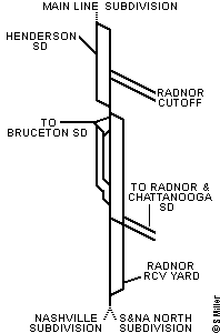 |
174.7 | Montfort | End Mainline SD, NEDT Begin Nashville Terminal SD |
|
| 177.0 | Amqui | Jct Henderson SD | ||
| 181.0 | Maplewood | Jct Radnor Cutoff | ||
| 185.0 | CR Draw Bridge | Single Track | ||
| 186.0 | Church Street | |||
| 186.2 N0.0 J0.0 |
Kayne Avenue | |||
| 187.7 | Oak Street | |||
| 193.8 | Radnor Rcv Yard | |||
| 196.8 | Brentwood | End Nashville Term SD, SEDT Begin S&NA North SD, Begin Nashville SD |
||
| 5.8 Miles · Oak Street to Danley | ||||
| â SOUTH â | MP | Station | Siding | Notes |
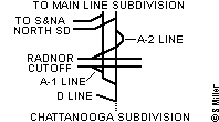 |
J1.4 | Oak Street | To S&NA North SD, Mainline SD | |
| J4.9 | Glencliff | SEDT, Jct Radnor Cutoff | ||
| J7.2 | Danley | End Nashville Terminal SD Begin Chattanooga SD |
||
| 4.4 Miles · Oak Street to Sellers | ||||
| â SOUTH â | MP | Station | Siding | Notes |
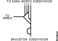 |
J1.4 | Oak Street | ||
| J0.0 N0.0 186.2 |
Kayne Avenue | |||
| N0.7 | 11th Avenue | |||
| N3.0 | Sellers | End Nashville Terminal SD SEDT, Begin Bruceton SD |
||
| 22.1 Miles · Maplewood to Radnor | ||||
| â SOUTH â | MP | Station | Siding | Notes |
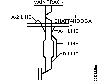 |
BA181.0 | Maplewood | ||
| BA184.8 | Shelby Park Bridge | |||
| BA188.3 | North Radnor | |||
| BA192.0 | Hump | |||
| BA193.8 | Radnor Rcv Yard | |||
| ||||||||||||||||||||||||||||||||||||||||||||||||||||
| ||||||||||||||||||||||||||||||||||||||||||||||||||||
Copyright © 2002 by Steven L. Miller. Reproduction is prohibited without permission.
This site is not affiliated with CSX Transportation, and is intended for informational purposes only.
Last updated - June 15, 2002